The Amanohashidate–Ine area spans Miyazu, Ine, Yosano and Kyotango on the Tango Peninsula in northern Kyoto Prefecture. From Amanohashidate, one of Japan's three celebrated scenic views, Route 178 follows the eastern coast past Ine's boathouses to Cape Kyogamisaki, the northernmost point of the Kinki region. It then continues along the Sea of Japan coast toward Tateiwa and Kotohikihama. This guide follows a day drive from Miyazu through Amanohashidate, Ine and Kyogamisaki to Kyotango, with roads and stops listed below.
Map of the Amanohashidate–Ine area
- Views and nature
- Roadside stations
- 1Michi-no-Eki Umi no Kyoto Miyazu
- 2Amanohashidate View Land
- 3Chionji Temple
- 4Kono Shrine
- 5Kasamatsu Park
- 6Ine Bay cruise
- 7Ine boathouses (funaya)
- 8Michi-no-Eki Funaya no Sato Ine
- 9Cape Kyoga
- 10Tango Matsushima
- 11Michi-no-Eki Tenki Tenki Tango
- 12Tateiwa Rock
- 13Kotohikihama Beach
- 14Michi-no-Eki Tango Kingdom
- 15Amanohashidate sandbar
- 16Nariaiji Temple
- 17Michi-no-Eki Silk no Machi Kaya
- 18Michi-no-Eki Maizuru Toretore Center
Line: 1 → 2 → 3 → 4 → 5 → 6 → 7 → 8 → 9 → 10 → 11 → 12 → 13 → 14
The map could not be loaded. Use the junction-by-junction directions below.
The line follows the first-day route from Amanohashidate through Ine and Cape Kyogamisaki to Kyotango. Numbers mark stops: green for viewpoints and nature, blue for roadside stations. Tap a number to see its name.
Recommended drives
A first day from Amanohashidate through Ine and Kyogamisaki to Kyotango
Start at Michi-no-Eki Umi-no-Kyoto Miyazu, visit Amanohashidate View Land and Chionji Temple, then drive around Aso Bay to Motoise Kono Shrine and Kasamatsu Park on the northern side. Follow Route 178 to the Ine Bay sightseeing cruise, the boathouses and Michi-no-Eki Funaya-no-Sato Ine. Continue past Cape Kyogamisaki, Tango Matsushima and Tateiwa to Kotohikihama and Michi-no-Eki Tango Kingdom. The route is about 81km, with roughly 1 hour 30 minutes of driving. Distances and times are calculated from map data and exclude traffic. The route uses ordinary roads throughout and has no tolls.
Cars cannot cross the Amanohashidate sandbar. To get from Monju on the southern side to Fuchu on the northern side, drive around Aso Bay. Crossing the sandbar on foot takes about 50 minutes each way, or about 20 minutes by bicycle.
See Amanohashidate from the south and north
Reach Amanohashidate View Land on the south side by monorail or chairlift. A return ticket costs ¥1,000, including admission. On the north side, a return cable car or chairlift ticket to Kasamatsu Park costs ¥800. The combined ticket for both viewpoints costs ¥1,700 for adults and is valid for 2 days.
See Ine's boathouses from the water and hillside
Ine Bay sightseeing boats leave on the hour and half-hour from 9:00 to 16:00, with adult tickets at ¥1,200. For a view from above, head to Michi-no-Eki Funaya-no-Sato Ine on the hillside. The boathouses are private homes: do not enter their grounds. Keep noise down at night and early in the morning, and avoid leaving your engine idling in car parks.
Roads you can drive
| Road | Where it goes | Length and toll | Hours and restrictions |
|---|---|---|---|
| Kyoto Jukan Expressway, Ayabe–Miyazu Road | Ayabe JCT via Maizuru-Oe IC to Miyazu-Amanohashidate IC | 23.4km; tolled | Sonobe IC–Miyazu-Amanohashidate IC closes in both directions from 20:00 to 6:00 the next morning on 26–30 October |
| San-in Kinki Expressway | Miyazu-Amanohashidate IC via Yosa-Amanohashidate IC to Kyotango-Omiya IC | ¥150 for an ordinary car; tolled since 1 April 2025 | ETC commuting-hour rate of ¥120 at 7:00–9:00 and 17:00–19:00; no holiday discount |
| Maizuru-Wakasa Expressway | From Osaka and Kobe via Yoshikawa JCT and Ayabe JCT to Maizuru-Nishi IC | Tolled | — |
| Route 178 | Maizuru through Miyazu, Amanohashidate, Ine and Kyogamisaki to Amino, around the Tango Peninsula | Free | 3 sections close in heavy rain. Kamanyu in Ine to Sodeshi in Kyotango closes at 150mm over 48 hours, with no diversion |
| Route 176 | Yosa Pass through Yosano to central Miyazu | Free | About 25 minutes from Yosa-Amanohashidate IC to Michi-no-Eki Silk-no-Machi Kaya |
| Road around Amanohashidate | Monju, near Amanohashidate Station and Chionji, around Aso Bay to Fuchu, near Kasamatsu Park and Kono Shrine | Free | No cars on the sandbar. Mopeds up to 125cc may cross except from 14 July to 31 August |
The rainfall closure sections on Route 178 are Yura–Kunda in Miyazu (200mm over 48 hours), Satohami–Nagae in Miyazu (170mm), and Kamanyu in Ine–Sodeshi in Kyotango (150mm). In winter, winter tyres or chains are required on snowy or icy roads and mountain passes.
Places to stop
Views and nature
Numbers match the map.
| No. | Place | Parking | What to know |
|---|---|---|---|
| 2 | Amanohashidate View Land | 17 car spaces; ¥700 a day, cash paid in advance | Return monorail or chairlift ¥1,000; 9:00–17:30 through 15 November, closing at 17:00 from 16 November |
| 3 | Chionji Temple | 100 spaces; ¥700 | At the southern entrance to Amanohashidate |
| 4 | Motoise Kono Shrine | 150 spaces; first 30 minutes free, ¥800 a day | 8:00–17:00 |
| 5 | Kasamatsu Park | No dedicated car park; use Kono Shrine parking or another nearby car park | Return cable car ¥800; open until 17:30 in November |
| 6 | Ine Bay sightseeing cruise | — | 9:00–16:00, departures on the hour and half-hour; adults ¥1,200 |
| 7 | Ine boathouses | Paid parking: Ineura Park 22 spaces, Onishi 37, Shichimensan 57 | About 230 boathouses line the bay; narrow roads make passing difficult |
| 9 | Cape Kyogamisaki | — | The northernmost point of Kinki; Kyogamisaki Park, about 1km from Route 178, overlooks the Sea of Japan and the lighthouse at 140m above sea level |
| 10 | Tango Matsushima | — | Rocks and pines seen near Inugamisaki Tunnel on Route 178; sunrise and sunset views from spring to early summer |
| 12 | Tateiwa | Nearby Michi-no-Eki Tenki-Tenki Tango; 53 spaces, free | A large rock about 1km around |
| 13 | Kotohikihama | — | A 1.8km singing-sand beach; a national scenic site and natural monument; no smoking |
| 15 | Amanohashidate sandbar | Miyazu municipal Amanohashidate car park: 224 spaces; ¥350 an hour, maximum ¥700; 9:00–17:00 | About 3.6km long with roughly 5,400 pines; free to walk; bicycle hire ¥500 for 2 hours |
| 16 | Nariaiji Temple | — | Overlooks Amanohashidate; no vehicle access uphill from 16:00 on the autumn illumination dates, 14 and 15 November |
Roadside stations
| No. | Roadside station | Parking | What to know |
|---|---|---|---|
| 1 | Michi-no-Eki Umi-no-Kyoto Miyazu | 56 spaces; 24 hours | About 2km from Miyazu-Amanohashidate IC; renewed on 1 October 2026; market and information center 9:00–17:00 |
| 8 | Michi-no-Eki Funaya-no-Sato Ine | 137 spaces; free, 24 hours | On a hill overlooking Ine Bay; 9:00–17:00, normally closed Tuesdays |
| 11 | Michi-no-Eki Tenki-Tenki Tango | 53 spaces; free, 24 hours | On Route 178; 2 EV chargers |
| 14 | Michi-no-Eki Tango Kingdom, Shoku-no-Miyako | 532 spaces; 24 hours | 9:00–17:00 weekdays, 9:00–21:00 weekends and holidays (restaurants only after 17:00); closed Tuesdays; EV charging |
| 17 | Michi-no-Eki Silk-no-Machi Kaya | 80 spaces; 24 hours | On Route 176; market 9:00–17:00 |
| 18 | Michi-no-Eki Maizuru Port Tore-Tore Center | 208 spaces; 24 hours | About 15 minutes from Maizuru-Nishi IC; 9:00–17:00 |
Best seasons and crowds
| Season | What to expect |
|---|---|
| Spring to early summer | Sunrise and sunset at Tango Matsushima |
| Summer | Swimming at Shotenkyo; mopeds cannot cross Amanohashidate from 14 July to 31 August |
| 14 and 15 November | Nariaiji autumn illuminations, 17:00–21:00, ¥1,000. No uphill car access from 16:00; use the cable car and shuttle bus from temporary parking at the foot of the hill |
| Winter | Crab dishes and yellowtail hotpot; winter tyres or chains required on snowy or icy roads and passes |
Sunset in Kyoto City is at 17:04 on 31 October and 16:52 on 15 November.
Busy places and times
- Roads around Amanohashidate get busy during the tourist season. On long holiday weekends, a park-and-cruise service uses Miyazu's municipal multi-storey car park (437 spaces, free for up to 5 hours), with a sightseeing boat onward to Amanohashidate.
- Miyazu municipal Amanohashidate car park charges a special rate from 27 April to 6 May and 10–16 August: ¥500 an hour, maximum ¥2,000.
- Roads around the Ine boathouses are narrow, and Ineura Park has just 22 parking spaces. Michi-no-Eki Funaya-no-Sato Ine on the hill has 137 free spaces.
Road closures and restrictions (26 October)
- The Kyoto Jukan Expressway between Sonobe IC and Miyazu-Amanohashidate IC closes in both directions from 20:00 to 6:00 the following morning on 26–30 October.
- Amanohashidate View Land closes for works on 15–17 December. The chairlift also stops for part of the day on 18–19 November and for the whole day on 14 and 18 December. Only the monorail runs during these stoppages, increasing waiting times.
- Kasamatsu Park closes on 18 December.
- Cars cannot drive up to Nariaiji from 16:00 on 14 and 15 November.
Getting there and fuel
| Starting point | Approximate drive |
|---|---|
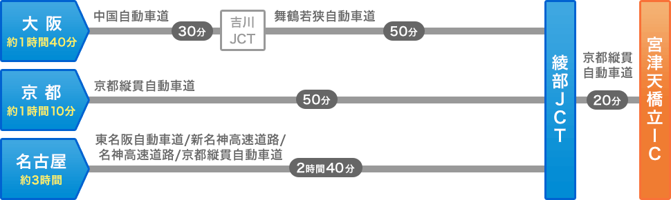
| Kyoto | About 1 hour 10 minutes to Miyazu-Amanohashidate IC on the Kyoto Jukan Expressway |
| Osaka | About 1 hour 40 minutes to Miyazu-Amanohashidate IC via the Chugoku, Maizuru-Wakasa and Kyoto Jukan expressways |
| Nagoya | About 3 hours to Miyazu-Amanohashidate IC |
| Miyazu-Amanohashidate IC | About 10 minutes to Amanohashidate; 45 minutes via Route 178 to Michi-no-Eki Funaya-no-Sato Ine |
| Kyotango-Omiya IC | About 15km, 20 minutes to Michi-no-Eki Tango Kingdom |
| Maizuru-Nishi IC | About 15 minutes to Michi-no-Eki Maizuru Port Tore-Tore Center |
Refuel in Miyazu or central Kyotango before heading along the outer peninsula between Ine and Kyogamisaki. EV charging is available at Michi-no-Eki Tenki-Tenki Tango and Tango Kingdom.
If you don't have a car
Before hiring a car, read the guides to driving documents in Japan and airport car rental pickup.
Frequently asked questions
Where should I go for a day around Amanohashidate and Ine?
From Miyazu, visit Amanohashidate View Land and Kasamatsu Park, then follow Route 178 to Ine's boathouses. Continue around Cape Kyogamisaki to Tango Kingdom in Kyotango. The route is about 81km, with roughly 1 hour 30 minutes of driving and no tolls.
Can I drive across Amanohashidate?
No. Walk or cycle across the sandbar: about 50 minutes on foot each way, or about 20 minutes by bicycle. Cars must go around Aso Bay.
Can I park near Ine's boathouses?
There are paid car parks at Ineura Park (22 spaces), Onishi (37) and Shichimensan (57). Michi-no-Eki Funaya-no-Sato Ine has 137 free spaces.
Is the San-in Kinki Expressway free?
It has been tolled since 1 April 2025. Ordinary cars pay ¥150 at the Miyazu-Amanohashidate mainline toll plaza.
Can I drive in winter?
Winter tyres or chains are required on snowy or icy roads and passes.
Nearby areas and guides
Sources & verification
Last verified: 2026-10-26
- Kyoto Prefecture (official page, in Japanese) · 2026-10-26
- NEXCO West Japan (official page, in Japanese) · 2026-10-26
- Kyoto Road Public Corporation (official page, in Japanese) · 2026-10-26
- Kyoto Road Public Corporation (official page, in Japanese) · 2026-10-26
- Kyoto Road Public Corporation (official page, in Japanese) · 2026-10-26
- Amanohashidate Tourism Association (official page, in Japanese) · 2026-10-26
- Amanohashidate Tourism Association (official page, in Japanese) · 2026-10-26
- Amanohashidate Tourism Association (official page, in Japanese) · 2026-10-26
- Kyoto Road Public Corporation (official page, in Japanese) · 2026-10-26
- Kyoto Prefecture (official page, in Japanese) · 2026-10-26
- Michi-no-Eki Tango Kingdom (official page, in Japanese) · 2026-10-27
- Motoise Kono Shrine (official page, in Japanese) · 2026-10-26
- Michi-no-Eki Umi-no-Kyoto Miyazu (official page, in Japanese) · 2026-10-26
- Kyoto Road Public Corporation (official page, in Japanese) · 2026-10-26
- Kyoto Road Public Corporation (official page, in Japanese) · 2026-10-26
- Kyoto Prefecture (official page, in Japanese) · 2026-10-26
- MLIT Kinki Regional Development Bureau (official page, in Japanese) · 2026-10-26
- Kyoto Prefecture (official page, in Japanese) · 2026-10-26
- MLIT Kinki Regional Development Bureau (official page, in Japanese) · 2026-10-26
- MLIT Kinki Regional Development Bureau (official page, in Japanese) · 2026-10-26
- Kyoto Prefecture (official page, in Japanese) · 2026-10-26
- Kyoto Prefecture (official page, in Japanese) · 2026-10-26
- Kyoto Prefecture (official page, in Japanese) · 2026-10-26
- Kyoto Prefecture (official page, in Japanese) · 2026-10-26
- Kyoto Prefecture (Civil Engineering Disaster Prevention) (official page, in Japanese) · 2026-10-26
- Ine Tourism Association (official page, in Japanese) · 2026-10-26
- Kyoto Prefecture (official page, in Japanese) · 2026-10-26
- Kyoto Prefecture (official page, in Japanese) · 2026-10-26
- Kyoto Prefecture Road Information System (official page, in Japanese) · 2026-10-26
- Kyoto Prefecture (official page, in Japanese) · 2026-10-26
- MLIT Kinki Regional Development Bureau (official page, in Japanese) · 2026-10-26
- MLIT Kinki Regional Development Bureau (official page, in Japanese) · 2026-10-26
- Amanohashidate Tourism Association (official page, in Japanese) · 2026-10-26
- Amanohashidate Tourism Association (official page, in Japanese) · 2026-10-26
- Tango Kairiku Kotsu (official page, in Japanese) · 2026-10-26
- Tango Kairiku Kotsu (official page, in Japanese) · 2026-10-26
- Amanohashidate Tourism Association (official page, in Japanese) · 2026-10-26
- Amanohashidate Tourism Association (official page, in Japanese) · 2026-10-26
- Amanohashidate Tourism Association (official page, in Japanese) · 2026-10-26
- Amanohashidate View Land (official page, in Japanese) · 2026-10-26
- Amanohashidate View Land (official page, in Japanese) · 2026-10-26
- Amanohashidate View Land (official page, in Japanese) · 2026-10-26
- Amanohashidate View Land (official page, in Japanese) · 2026-10-26
- Amanohashidate View Land (official page, in Japanese) · 2026-10-26
- Amanohashidate View Land (official page, in Japanese) · 2026-10-26
- Amanohashidate View Land (official page, in Japanese) · 2026-10-26
- Amanohashidate Tourism Association (official page, in Japanese) · 2026-10-26
- Amanohashidate View Land (official page, in Japanese) · 2026-10-26
- Tango Kairiku Kotsu (official page, in Japanese) · 2026-10-26
- Tango Kairiku Kotsu (official page, in Japanese) · 2026-10-26
- Tango Kairiku Kotsu (official page, in Japanese) · 2026-10-26
- Motoise Kono Shrine (official page, in Japanese) · 2026-10-26
- Amanohashidate Tourism Association (official page, in Japanese) · 2026-10-27
- Tango Kairiku Kotsu (official page, in Japanese) · 2026-10-26
- Tango Kairiku Kotsu (official page, in Japanese) · 2026-10-26
- Kyoto Prefecture (official page, in Japanese) · 2026-10-26
- Amanohashidate Tourism Association (official page, in Japanese) · 2026-10-26
- Amanohashidate Tourism Association (official page, in Japanese) · 2026-10-26
- Tango Kairiku Kotsu (official page, in Japanese) · 2026-10-26
- Tango Kairiku Kotsu (official page, in Japanese) · 2026-10-26
- Motoise Kono Shrine (official page, in Japanese) · 2026-10-26
- Ine Tourism Association (official page, in Japanese) · 2026-10-26
- Tango Kairiku Kotsu (official page, in Japanese) · 2026-10-26
- Kyoto Prefecture (official page, in Japanese) · 2026-10-26
- Ine Town (official page, in Japanese) · 2026-10-26
- Ine Tourism Association (official page, in Japanese) · 2026-10-26
- Ine Tourism Association (official page, in Japanese) · 2026-10-26
- Tango Kairiku Kotsu (official page, in Japanese) · 2026-10-26
- Ine Tourism Association (official page, in Japanese) · 2026-10-26
- Kyotango City (official page, in Japanese) · 2026-10-26
- Michi-no-Eki Tenki-Tenki Tango (official page, in Japanese) · 2026-10-26
- Kyotango City (official page, in Japanese) · 2026-10-26
- Amanohashidate Tourism Association (official page, in Japanese) · 2026-10-26
- MLIT Kinki Regional Development Bureau (official page, in Japanese) · 2026-10-26
- MLIT Kinki Regional Development Bureau (official page, in Japanese) · 2026-10-26
- Japan Meteorological Agency (official page, in Japanese) · 2026-10-26
- Kyoto Prefecture (official page, in Japanese) · 2026-10-26
- Kyoto Prefecture (official page, in Japanese) · 2026-10-26
- Amanohashidate Tourism Association (official page, in Japanese) · 2026-10-26
- National Astronomical Observatory of Japan (official page, in Japanese) · 2026-10-26
- National Astronomical Observatory of Japan (official page, in Japanese) · 2026-10-26
- National Astronomical Observatory of Japan (official page, in Japanese) · 2026-10-26
- Japan Meteorological Agency (official page, in Japanese) · 2026-10-26
- OpenStreetMap (map positions and route; © OpenStreetMap contributors, ODbL; route calculated with OSRM) · 2026-10-26
- Amanohashidate View Land (official page, in Japanese) · 2026-10-27