The Karuizawa area is centred on the town of Karuizawa in Nagano Prefecture. By car you can take in the old town of Kyu-Karuizawa and Kumoba Pond, Shiraito Falls and Onioshidashi at the foot of Mt. Asama, and the Megane-bashi bridge on the Gunma side of Usui Pass. It takes about 20 minutes from Usui-Karuizawa IC on the Joshin-etsu Expressway to Kumoba Pond. This page sets out a one-day route from the town to the foot of Mt. Asama and how to enter the area and avoid the traffic, and lists the roads and places to stop.
Map of the Karuizawa area
- Views and nature
- 1Karuizawa Prince Shopping Plaza
- 2Kumobaike Pond
- 3Kyu-Karuizawa Ginza
- 4Usui Pass Lookout
- 5Shiraito Falls
- 6Onioshidashi Park
- 7Hoshino Area
- 8Megane Bridge
- 9Ryugaeshi Falls
Line: 1 → 2 → 3 → 4 → Shiraito Highland Way → 5 → Onioshi Highway → 6 → Route 146 → 7 → 1
The map could not be loaded. Use the junction-by-junction directions below.
The line on the map is the route described below under "First visit: one day from Kyu-Karuizawa to Shiraito Falls and Onioshidashi". The numbers are places to stop. Hover over or tap a number to see its name.
Recommended drives
First visit: one day from Kyu-Karuizawa to Shiraito Falls and Onioshidashi
Start at Karuizawa Prince Shopping Plaza, south of Karuizawa Station. Go round Kumoba Pond and Kyu-Karuizawa Ginza, then climb to the Kyu-Usui Pass Viewpoint. From Mikasa, enter the Shiraito Highland Way and stop at Shiraito Falls, then take the Onioshi Highway from Minenochaya to Onioshidashi Park. On the way back, come down Route 146, stop at the Hoshino Area and return to the station area. The loop is about 49 km and about 1 hour 25 minutes of driving. Distance and time are calculated from map data and do not include traffic.
The tolls are ¥500 for the Shiraito Highland Way and ¥280 for the Karuizawa section of the Onioshi Highway, ¥780 in total for a standard car. The Shiraito Highland Way takes cash or credit cards. From 16 to 20 November, 8:00–17:00, the Mikasa side is closed. During that time, enter from Minenochaya and turn back at Shiraito Falls.
Kumoba Pond has no car park of its own, and parking on the roads around it is prohibited. Park at a town car park (west of the north exit of Karuizawa Station, or Yagasaki Park) and walk. The road up to the Kyu-Usui Pass Viewpoint is closed to large vehicles.
Down Usui Pass by the old road to Megane-bashi
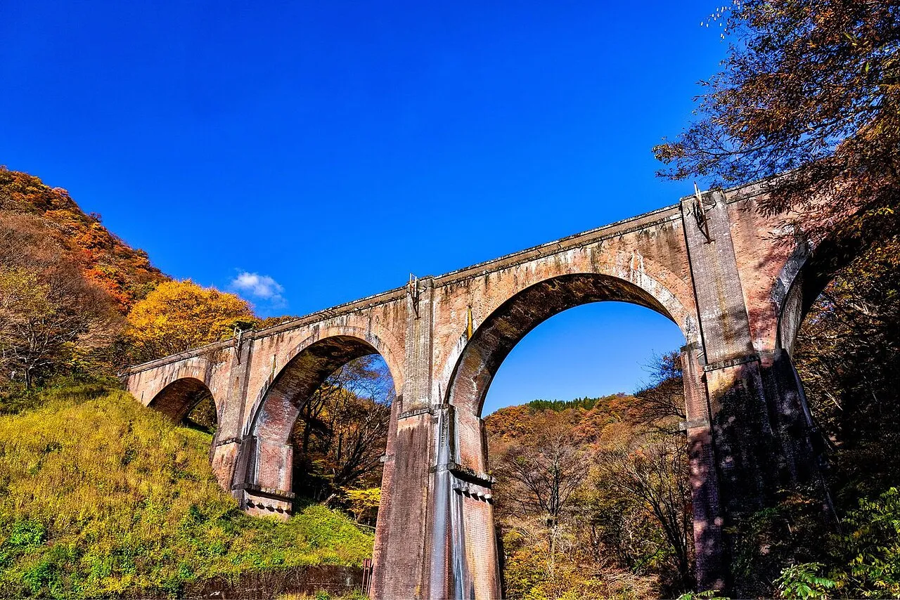
From Kyu-Karuizawa, go down Usui Pass on the old Route 18 to reach Megane-bashi (Usui No. 3 Bridge) in Annaka, Gunma. It is a brick bridge with four arches, completed in 1892 (Meiji 25), and an Important Cultural Property. The car park holds 22 standard cars. The old road over Usui Pass is narrow, so drive slowly.
On holidays, enter by an interchange other than Usui-Karuizawa
On holiday weekends, the road from Usui-Karuizawa IC into the town jams. Getting off at Matsuida-Myogi IC or Sakudaira Smart IC when coming from Tokyo, or at Komoro IC, Saku IC or Sakudaira Smart IC when coming from Nagano, shortens the trip. Sakudaira Smart IC is for ETC cars only.
Roads you can drive
| Road | What it is | Length and toll | Hours and rules |
|---|---|---|---|
| Joshin-etsu Expressway | To Karuizawa from Usui-Karuizawa IC, Sakudaira Smart IC and Matsuida-Myogi IC | Varies by section | Sakudaira Smart IC is ETC only and open 24 hours |
| Route 18, Usui Bypass | Bypass climbing from Yokokawa in Gunma to Karuizawa | 15.6 km, free | Closed at 150 mm of continuous rain. May be closed in advance for heavy snow |
| Route 18, old road (Usui Pass) | Old road over Usui Pass past Megane-bashi | 12.5 km, free | Closed at 120 mm of continuous rain. Narrow |
| Route 18 (in Karuizawa town) | Runs east–west through the town | Free | One lane closed near the town hall until 25 December (20:00–5:00 from 1 November to 18 December) |
| Route 146 | From Naka-Karuizawa through Minenochaya to Kita-Karuizawa | Free | — |
| Shiraito Highland Way | Toll road from Mikasa past Shiraito Falls to Minenochaya | 10 km, ¥500 for a standard car. Cash or credit card | Mikasa side closed 8:00–17:00 on 16–20 November. Studless winter tyres or chains required from mid-November to mid-April |
| Onioshi Highway | From Minenochaya through Onioshidashi to Kita-Karuizawa and Tsumagoi | Karuizawa section 6.3 km, ¥280; Kanbara section 9.3 km, ¥370 | Cash, cards, transport IC cards and others accepted |
| Roads around Kyu-Karuizawa | Around Kyu-Karuizawa Ginza and Kumoba Pond | — | Kyu-Karuizawa Ginza is pedestrian-only 11:00–18:00 on weekends and holidays until 30 November. The road on the south side of Kumoba Pond is one-way 8:15–17:00 until 15 November (also 20–24 November) |
Places to stop
Views and nature
The numbers match the map.
| No. | Place | Parking | Notes |
|---|---|---|---|
| 1 | Karuizawa Prince Shopping Plaza | About 3,500 cars. Free for 2 hours, then ¥100 per hour (cash only) | South of Karuizawa Station. About 14 minutes from Usui-Karuizawa IC |
| 2 | Kumoba Pond | No car park of its own. Walk from town car parks such as Yagasaki Park (65 cars, free for under 2 hours) | Autumn leaves usually mid-October to early November. Shuttle bus from Karuizawa Station until 23 November (¥220) |
| 3 | Kyu-Karuizawa Ginza | Kyu-Karuizawa town car park, 213 cars. ¥500 for under 1 hour | In the tourist season you may wait a long time to get into the car park |
| 4 | Kyu-Usui Pass Viewpoint | Number of spaces not published | 1,200 m. Views of Mt. Asama and the Yatsugatake range. Carry a bear bell |
| 5 | Shiraito Falls | About 200 standard cars, free | On the Shiraito Highland Way. The ¥500 toll is separate |
| 6 | Onioshidashi Park | 750 cars, free | At the foot of Mt. Asama (Tsumagoi, Gunma). 8:00–17:00, adults ¥700 to enter |
| 7 | Karuizawa Hoshino Area | Paid P1–P3 (30 minutes free, then ¥600 per hour) and free P6 and P7 | On weekends and holidays the car parks tend to fill from 10:00 to 15:00 |
| 8 | Megane-bashi (Usui No. 3 Bridge) | 22 standard cars, 4 large buses | Can be viewed 24 hours a day. Autumn leaves usually early to mid-November |
| — | Ryugaeshi Falls | Enter from the Oze Onsen bus stop and it is right there (not for large vehicles) | About 15 minutes' walk from the car park to the falls |
Roadside stations
Karuizawa town has no roadside station (michi-no-eki). Nearby there are Michi-no-Eki Raiden Kurumi no Sato in Tomi (100 standard cars; car park and toilets open 24 hours) and Michi-no-Eki Yamba Furusato-kan in Naganohara (177 standard cars).
Best seasons and crowds
| When | What to see |
|---|---|
| Mid-October to early November | Autumn leaves at Kumoba Pond |
| Early to mid-November | Autumn leaves at Megane-bashi on Usui Pass and Lake Usui |
| August, December–February | Shiraito Falls lit up (usually) |
| Winter | Winter tyres are needed on snowy days. The Shiraito Highland Way requires studless winter tyres or chains from mid-November to mid-April |
Busy places and times
- On holiday weekends, the road from Usui-Karuizawa IC into the town and Prince-dori are very busy.
- The Kyu-Karuizawa car park can have a long wait in the tourist season. Do not wait in the road.
- The Hoshino Area car parks tend to fill from about 11:00 to 14:00 on weekdays and from 10:00 to 15:00 on weekends and holidays, with the jam starting from the Naka-Karuizawa Station side. If they are full, go to P6 and P7.
- Town traffic information is broadcast on FM Karuizawa (77.5 MHz).
Closures and restrictions (as of 26 October)
- The volcanic alert level for Mt. Asama is 1. You cannot enter the area within 500 m of the crater. Volcanic earthquakes have increased slightly since late September, but the situation does not call for a higher level.
- The road on the south side of Kumoba Pond is one-way from the Rokuhon-tsuji side, 8:15–17:00, until 15 November (also 20–24 November).
- On Route 18, one lane is closed east of Yagasaki Bridge until 31 October and near the town hall until 25 December.
- Prefectural Road 43 is down to one lane near Hotchi until 30 November.
- The Shiraito Highland Way is closed on the Mikasa side from 16 to 20 November, 8:00–17:00.
Getting there and fuel
| From | Time |
|---|---|
| Joshin-etsu Expressway, Usui-Karuizawa IC | About 20 minutes to Kumoba Pond, about 50 minutes to Shiraito Falls, about 45 minutes to Onioshidashi Park |
| Joshin-etsu Expressway, Sakudaira Smart IC | About 20 minutes to the Hoshino Area |
| Joshin-etsu Expressway, Komoro IC | About 30 minutes to the Hoshino Area, about 50 minutes to Onioshidashi Park |
| Joshin-etsu Expressway, Matsuida-Myogi IC | About 15 minutes to Megane-bashi |
In heavy winter snow, the Joshin-etsu Expressway, the Route 18 Usui Bypass and the old road may be closed in advance. On 4 March 2025, all three were closed at once.
There is no official list of petrol stations in the town. The Yokokawa Service Area on the Joshin-etsu Expressway has fuel 24 hours in both directions, so fill up there before climbing to Minenochaya or Kita-Karuizawa. You can charge an electric car at P1 in the Hoshino Area and at Michi-no-Eki Raiden Kurumi no Sato.
If you don't have a car
Driving in Japan on a foreign licence needs a 1949 Geneva international driving permit or an official Japanese translation; see Driving in Japan on a Foreign License. If you are picking up a car at the airport, see Renting a Car at Haneda, Narita or Kansai Airport: Pickup and Return.
Frequently asked questions
What is the best one-day drive in Karuizawa?
Go round Kumoba Pond and Kyu-Karuizawa Ginza, climb to the Kyu-Usui Pass Viewpoint, drive the Shiraito Highland Way to Shiraito Falls and the Onioshi Highway to Onioshidashi Park, then stop at the Hoshino Area on the way back. It is about 49 km and about 1 hour 25 minutes of driving, with tolls of ¥780 in total.
Is there a car park at Kumoba Pond?
No. Parking on the surrounding roads is prohibited, so park at the town's Yagasaki Park car park or the car park west of the north exit of Karuizawa Station and walk, or take the shuttle bus from Karuizawa Station.
How do I avoid holiday traffic?
Avoid Usui-Karuizawa IC. Get off at Matsuida-Myogi IC or Sakudaira Smart IC when coming from Tokyo, or at Komoro IC or Saku IC when coming from Nagano.
Can I get close to Mt. Asama now?
The volcanic alert level is 1, and only the area within 500 m of the crater is off limits. You can visit Onioshidashi Park and Shiraito Falls as usual.
Can I go to Shiraito Falls in winter?
No winter closure has been announced for the Shiraito Highland Way, but from mid-November to mid-April you need studless winter tyres or chains. All-season tyres cannot be used, even with the snowflake mark.
Nearby areas and guides
Sources & verification
Last verified: 2026-10-26
- Go NAGANO (Nagano Tourism Organization) (official page, in Japanese) · 2026-10-26
- Nagano Prefecture (official page, in Japanese) · 2026-10-26
- Japan Meteorological Agency (official page, in Japanese) · 2026-10-26
- Shiraito Highland Way (official page, in Japanese) · 2026-10-26
- Shiraito Highland Way (official page, in Japanese) · 2026-10-26
- MLIT Kanto Regional Development Bureau (official page, in Japanese) · 2026-10-26
- Karuizawa Town (official page, in Japanese) · 2026-10-26
- Karuizawa Hoshino Area (official page, in Japanese) · 2026-10-26
- Prince Hotels (Onioshidashi Park and Onioshi Highway) (official page, in Japanese) · 2026-10-26
- NEXCO East Japan (Drive Plaza) (official page, in Japanese) · 2026-10-26
- NEXCO East Japan (Drive Plaza) (official page, in Japanese) · 2026-10-26
- Karuizawa Hoshino Area (official page, in Japanese) · 2026-10-26
- Michi-no-Eki Raiden Kurumi no Sato (official page, in Japanese) · 2026-10-26
- Gunma Prefecture road restriction information (official page, in Japanese) · 2026-10-26
- Nagano Prefecture (official page, in Japanese) · 2026-10-26
- Shiraito Highland Way (official page, in Japanese) · 2026-10-26
- MLIT Kanto Regional Development Bureau (official page, in Japanese) · 2026-10-26
- MLIT Kanto Regional Development Bureau (official page, in Japanese) · 2026-10-26
- Karuizawa Town (official page, in Japanese) · 2026-10-26
- Karuizawa Town (official page, in Japanese) · 2026-10-26
- Karuizawa Town (official page, in Japanese) · 2026-10-26
- Shiraito Highland Way (official page, in Japanese) · 2026-10-26
- Michi-no-Eki Yamba Furusato-kan (official page, in Japanese) · 2026-10-26
- Go NAGANO (Nagano Tourism Organization) (official page, in Japanese) · 2026-10-26
- Annaka City (official page, in Japanese) · 2026-10-26
- Karuizawa Town (official page, in Japanese) · 2026-10-26
- Prince Hotels (Onioshidashi Park and Onioshi Highway) (official page, in Japanese) · 2026-10-26
- NEXCO East Japan (Drive Plaza) (official page, in Japanese) · 2026-10-26
- NEXCO East Japan (Drive Plaza) (official page, in Japanese) · 2026-10-26
- NEXCO East Japan (Dora-tora traffic information) (official page, in Japanese) · 2026-10-26
- Karuizawa Tourism Association (official page, in Japanese) · 2026-10-26
- NEXCO East Japan (Drive Plaza) (official page, in Japanese) · 2026-10-26
- MLIT Kanto Regional Development Bureau (official page, in Japanese) · 2026-10-26
- MLIT Kanto Regional Development Bureau (official page, in Japanese) · 2026-10-26
- Annaka City (official page, in Japanese) · 2026-10-26
- Karuizawa Prince Shopping Plaza (official page, in Japanese) · 2026-10-26
- Nagano Prefecture (official page, in Japanese) · 2026-10-26
- Karuizawa Town (official page, in Japanese) · 2026-10-26
- Karuizawa Town (official page, in Japanese) · 2026-10-26
- Karuizawa Town (official page, in Japanese) · 2026-10-26
- Shiraito Highland Way (official page, in Japanese) · 2026-10-26
- Shiraito Highland Way (official page, in Japanese) · 2026-10-26
- Karuizawa Town (official page, in Japanese) · 2026-10-26
- Karuizawa Town (official page, in Japanese) · 2026-10-26
- Karuizawa Town (official page, in Japanese) · 2026-10-26
- Karuizawa Town (official page, in Japanese) · 2026-10-26
- Prince Hotels (Onioshidashi Park and Onioshi Highway) (official page, in Japanese) · 2026-10-26
- Karuizawa Tourism Association (official page, in Japanese) · 2026-10-26
- Karuizawa Prince Shopping Plaza (official page, in Japanese) · 2026-10-26
- Karuizawa Prince Shopping Plaza (official page, in Japanese) · 2026-10-26
- Kanto Michi-no-Eki Association (official page, in Japanese) · 2026-10-26
- Kanto Michi-no-Eki Association (official page, in Japanese) · 2026-10-26
- OpenStreetMap (map positions and route; © OpenStreetMap contributors, ODbL; route calculated with OSRM) · 2026-10-26