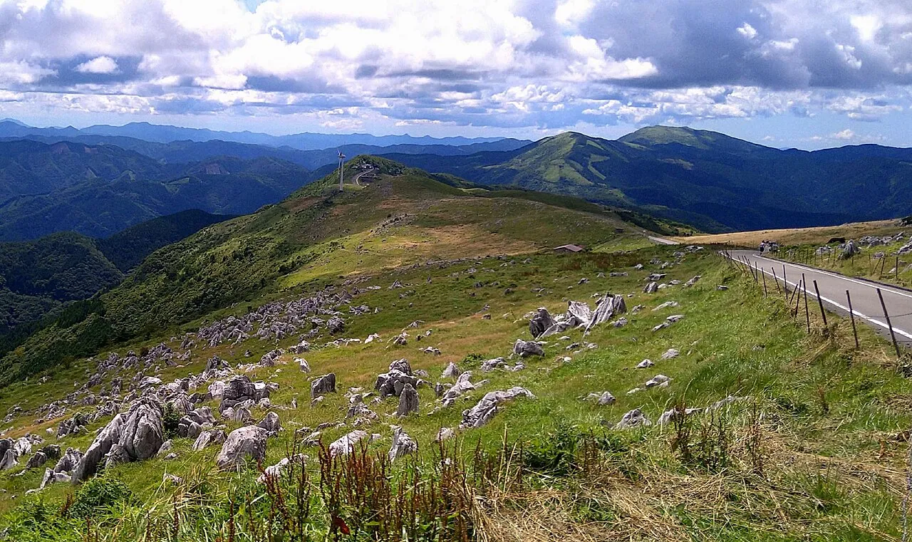
The Shikoku Karst area is a plateau of limestone grassland that spans Kumakogen Town and Seiyo City in Ehime Prefecture and Tsuno Town and Yusuhara Town in Kochi Prefecture. From Tengu-kogen in the east, through Godan-kogen and Himetsuru-daira, to Onogahara in the west, the plateau is linked by Prefectural Road 383 (the Shikoku Karst Park Road, 14.8 km). This page sets out a one-day drive that climbs from the Kochi side, runs west along the plateau and comes down on the Ehime side, and lists the roads and places to stop.
Map of the Shikoku Karst area
- Views and nature
- Roadside stations
- 1Michi-no-Eki Fusegasaka
- 2Tengu Kogen
- 3Godan Kogen
- 4Mezurudaira
- 5Genjigadaba
- 6Onogahara
- 7Jiyoshi Pass
- 8Michi-no-Eki Tenku-no-Sato Sansan
- 9Michi-no-Eki Mikawa
- 10Michi-no-Eki Yusuhara
Line: 1 → forest road → 2 → plateau road → 3 → 4 → 5 → 6 → 7 → Route 440 → 8
The map could not be loaded. Use the junction-by-junction directions below.
The line on the map is the route described below under "First visit: one day from Tengu-kogen to Onogahara". The numbers are places to stop: green for views and nature, blue for roadside stations (michi-no-eki). Hover over or tap a number to see its name.
Recommended drives
First visit: one day from Tengu-kogen to Onogahara
Start at Michi-no-Eki Fusegasaka on the Kochi side and climb to Tengu-kogen on Route 197 and the forest road (the Higashi-Tsuno Shirokawa Line). Drive west along the Park Road, stopping at Godan-kogen and Himetsuru-daira, and continue to Genjigadaba and Onogahara. Then go back to Jiyoshi Pass and come down on Route 440 to Michi-no-Eki Tenku no Sato Sansan on the Ehime side. It is about 107 km and about 2 hours of driving. Distance and time are calculated from map data and do not include traffic.
Apart from the forest road, the roads up to the plateau are narrow, and in places it is hard for two cars to pass. The forest road on the Kochi side is the only way up with two lanes. On foggy days you may see nothing. In fog, turn on your lights so that other cars can see you.
From Matsuyama, climb to Jiyoshi Pass
From Matsuyama the quickest way up is Route 33 and Route 440 to Jiyoshi Pass. The last 9 km or so are narrow. On Prefectural Road 36 (1.4 km), just before Jiyoshi Pass, the road can only be used from 0 to 10 minutes past each hour and from 12:00 to 13:10 on weekdays from 8:30 to 17:00, until 22 January 2027. There are no works at weekends.
For Onogahara, take Seiyo-Uwa IC
It is about 100 minutes from Seiyo-Uwa IC on the Matsuyama Expressway to Genjigadaba in Onogahara. Genjigadaba is the highest point in Onogahara, with a view over the whole plateau.
Roads you can drive
| Road | What it is | Length and toll | Hours and rules |
|---|---|---|---|
| Prefectural Road 383, Shikoku Karst Park Road | From Tengu-kogen through Godan-kogen, Himetsuru-daira and Jiyoshi Pass to Onogahara | 14.8 km, free | Fully closed in winter. The 2026 closing date has not been announced yet |
| Climb from the Matsuyama side | From Route 440 on Prefectural Road 36 to Jiyoshi Pass, or on Prefectural Road 303 to Tengu-kogen | Prefectural Road 36 is 1.4 km | Prefectural Road 36 is closed in the daytime on weekdays except for set times, until 22 January 2027 |
| Route 33 (Misaka Road) | From Matsuyama to Kumakogen | Free | Closed from 21:00 to 6:00 the next morning on 26–30 October, 2 November, 4–6 November and 9 November. Use Route 440 (the old Route 33) as a detour |
| Route 440 | From Kumakogen through the Jiyoshi Tunnel to Yusuhara | Free | The Komura Tunnel opened on 15 October |
| Climb from the Kochi side | From Susaki-Higashi IC on Route 197 and the forest road to Tengu-kogen | The Kochi Expressway is free as far as Susaki-Nishi IC | Two lanes all the way up. In winter, use the snow-cleared route on Route 439 and Prefectural Road 304 |
| Road from the Seiyo side | From Seiyo-Uwa IC on the Matsuyama Expressway to Onogahara | — | The Matsuyama Expressway between Ozu-Minami IC and Seiyo-Uwa IC is closed from 19:00 to 6:00 until the morning of 31 October |
Places to stop
Views and nature
The numbers match the map.
| No. | Place | Parking | Notes |
|---|---|---|---|
| 2 | Tengu-kogen, Hoshi Furu Village TENGU | 88 standard cars nearby, free | Lunch 11:00–14:30, closed Tuesdays and Wednesdays. Open in winter too |
| — | Karst Terrace (Tengu-kogen) | 3 standard cars, free | 9:00–17:00, closed Mondays. Free entry |
| 3 | Godan-kogen | Use the car park at Himetsuru-daira | Limestone rocks and cattle on the grassland. No facilities |
| 4 | Himetsuru-daira, Himetsuru-so | Free car parks nearby | Shop open 10:00–19:00. In 2026 the lodge is open until 15 November and the shop until 16 November |
| 5 | Genjigadaba | Car park available | The highest point in Onogahara |
| 6 | Onogahara | Car parks at Komatsugaike and other places | You can see black-and-white cattle. The road is closed in winter |
| 7 | Jiyoshi Pass | — | At the crossroads with the "Jiyoshi Pass" sign, turn left for Himetsuru-daira |
| — | Himetsuru-daira Campsite | One tent and one car are included in the fee | ¥1,500 a night (¥2,500 on Saturdays, the night before a public holiday and in busy periods) plus a ¥500 per person environment fee. Open for stays up to 22 November |
Roadside stations
| No. | Station | Parking | Notes |
|---|---|---|---|
| 1 | Michi-no-Eki Fusegasaka (Tsuno Town) | 55 standard cars, 3 large vehicles | The entrance on the Kochi side. About 35 minutes from Susaki-Higashi IC. EV charger |
| 8 | Michi-no-Eki Tenku no Sato Sansan (Kumakogen Town) | 71 standard cars, 3 large vehicles | On the Ehime side. The farm shop is open 9:00–17:00. EV charger |
| — | Michi-no-Eki Mikawa (Kumakogen Town) | 35 standard cars, 1 large vehicle | On Route 33. The shop is open 7:00–18:00 |
| — | Michi-no-Eki Yusuhara (Yusuhara Town) | Car park available | About 50 minutes from Susaki-Higashi IC. Open 8:30–17:30 (until 17:00 in winter) |
The car parks at all four roadside stations are open 24 hours.
Best seasons and crowds
| When | What to see and watch for |
|---|---|
| Late April to late October | Cattle grazing on the plateau |
| July | Sasa-yuri and Hime-yuri lilies in flower |
| Mid-September to early November | Pampas grass. From October to early November a sea of clouds often forms in the morning, and there are many fine days |
| Winter | The Park Road is fully closed. From late November you need chains or similar |
On 26 October the sun sets at 17:23 in Matsuyama and 17:20 in Kochi.
Crowds and cautions
- On long holidays such as Golden Week and Silver Week, many people come from inside and outside the prefectures. Queues start after noon and can stretch back from the front of Karst Terrace.
- On long holidays, no-parking signs go up at the passing places on the Park Road. Do not park in the passing places.
- When a thunderstorm warning or similar is in force, avoid walking on the plateau.
Closures and restrictions (as of 26 October)
- The Park Road is open now. The winter closure for 2026 has not been announced yet. In the last seven years the closure started between 24 November and 27 December.
- Prefectural Road 36 just before Jiyoshi Pass is closed except for set times on weekdays in the daytime until 22 January 2027.
- Route 33 (Misaka Road) is closed from 21:00 to 6:00 the next morning on the designated days from 26 October to 9 November.
- The Matsuyama Expressway between Ozu-Minami IC and Seiyo-Uwa IC is closed from 19:00 to 6:00 until the morning of 31 October.
Getting there and fuel
| From | Time |
|---|---|
| Susaki-Higashi IC (Kochi Expressway) | About 1 hour 20 minutes to Karst Terrace, about 35 minutes to Michi-no-Eki Fusegasaka |
| Susaki-Chuo IC (Kochi Expressway) | About 90 minutes to Shikoku Karst (Nagano, Yusuhara Town) |
| Matsuyama IC (Matsuyama Expressway) | About 30 minutes to the Kumakogen town office |
| Seiyo-Uwa IC (Matsuyama Expressway) | About 100 minutes to Onogahara |
The forest road on the Kochi side has two lanes and is easy to climb. If you are coming from Kagawa, Tokushima or the Seto-Ohashi Bridge, going via Susaki on the Kochi Expressway gets you there sooner. To reach Tengu-kogen from the Kochi side in winter, use the snow-cleared route on Route 439, Prefectural Road 304, the forest road and Prefectural Road 48. For closing and reopening dates across Japan, see Japan Winter Road Closures 2026–27.
There are no petrol stations on the plateau or at the roadside stations. It takes about 40 minutes from Himetsuru-daira to the centre of Yusuhara and about 1 hour to Kumakogen, so fill up before you climb.
If you don't have a car
Driving in Japan on a foreign licence needs a 1949 Geneva international driving permit or an official Japanese translation; see Driving in Japan on a Foreign License. If you are picking up a car at the airport, see Renting a Car at Haneda, Narita or Kansai Airport: Pickup and Return.
Frequently asked questions
What is the best one-day drive in Shikoku Karst?
Climb from the Kochi side on the forest road to Tengu-kogen, drive west along the Park Road through Godan-kogen, Himetsuru-daira, Genjigadaba and Onogahara, and come down to the Ehime side from Jiyoshi Pass. It is about 107 km and about 2 hours of driving.
Are the roads in Shikoku Karst narrow?
The forest road on the Kochi side has two lanes, but the other roads up are narrow and in places it is hard for two cars to pass. On the way up to Jiyoshi Pass from Matsuyama, the last 9 km or so are narrow.
Can I go to Shikoku Karst in winter?
The Park Road is fully closed in winter, and the section through Onogahara cannot be used either. You can reach Tengu-kogen by the snow-cleared route from the Kochi side, and some facilities there are open in winter. For closing dates across Japan, see Japan Winter Road Closures 2026–27.
When can I see the sea of clouds?
October to early November is the time when a sea of clouds often forms in the morning.
Can I buy petrol in Shikoku Karst?
There are no petrol stations on the plateau or at the roadside stations around it. Fill up in the town of Yusuhara or Kumakogen before you climb.
Nearby areas and guides
Sources & verification
Last verified: 2026-10-26
- Ehime Prefecture (official page, in Japanese) · 2026-10-26
- Yusuhara Kumo-no-Ue Tourism Association (official page, in Japanese) · 2026-10-26
- Ministry of Land, Infrastructure, Transport and Tourism (MLIT) (official page, in Japanese) · 2026-10-26
- Ehime Prefecture (official page, in Japanese) · 2026-10-26
- Himetsuru-so (official page, in Japanese) · 2026-10-26
- Himetsuru-so (official page, in Japanese) · 2026-10-26
- Kochi Tabi Net (Kochi Convention and Visitors Association) (official page, in Japanese) · 2026-10-26
- Himetsuru-so (official page, in Japanese) · 2026-10-26
- Ehime Prefecture (official page, in Japanese) · 2026-10-26
- Kumakogen Town (official page, in Japanese) · 2026-10-26
- MLIT Shikoku Regional Development Bureau (official page, in Japanese) · 2026-10-26
- MLIT Shikoku Regional Development Bureau (official page, in Japanese) · 2026-10-26
- Himetsuru-so (official page, in Japanese) · 2026-10-26
- Karst Terrace (official page, in Japanese) · 2026-10-26
- Himetsuru-so (official page, in Japanese) · 2026-10-26
- Ehime Prefecture (official page, in Japanese) · 2026-10-26
- Hoshi Furu Village TENGU (official page, in Japanese) · 2026-10-26
- Shikoku Seiyo Geopark (official page, in Japanese) · 2026-10-26
- MLIT Shikoku Regional Development Bureau (official page, in Japanese) · 2026-10-26
- NEXCO West Japan (official page, in Japanese) · 2026-10-26
- Ehime Prefecture (official page, in Japanese) · 2026-10-26
- Himetsuru-so (official page, in Japanese) · 2026-10-26
- Himetsuru-so (official page, in Japanese) · 2026-10-26
- Himetsuru-daira (Yanadani) (official page, in Japanese) · 2026-10-26
- Hoshi Furu Village TENGU (official page, in Japanese) · 2026-10-26
- National Astronomical Observatory of Japan (sunrise and sunset) (official page, in Japanese) · 2026-10-26
- National Astronomical Observatory of Japan (sunrise and sunset) (official page, in Japanese) · 2026-10-26
- Ehime Prefecture (official page, in Japanese) · 2026-10-26
- Ehime Prefecture (official page, in Japanese) · 2026-10-26
- Kochi Prefecture (official page, in Japanese) · 2026-10-26
- Kochi Prefecture (official page, in Japanese) · 2026-10-26
- Himetsuru-so (official page, in Japanese) · 2026-10-26
- Ehime Prefecture (official page, in Japanese) · 2026-10-26
- Kochi Prefecture (official page, in Japanese) · 2026-10-26
- Kochi Prefecture (official page, in Japanese) · 2026-10-26
- Kumakogen Town (official page, in Japanese) · 2026-10-26
- Michi-no-Eki Mikawa (official page, in Japanese) · 2026-10-26
- MLIT Shikoku Regional Development Bureau (official page, in Japanese) · 2026-10-26
- Kochi Prefecture (official page, in Japanese) · 2026-10-26
- Kochi Tabi Net (Kochi Convention and Visitors Association) (official page, in Japanese) · 2026-10-26
- NEXCO West Japan (official page, in Japanese) · 2026-10-26
- Shikoku Seiyo Geopark (official page, in Japanese) · 2026-10-26
- Shikoku Seiyo Geopark (official page, in Japanese) · 2026-10-26
- Shikoku Seiyo Geopark (official page, in Japanese) · 2026-10-26
- Himetsuru-so (official page, in Japanese) · 2026-10-26
- Himetsuru-so (official page, in Japanese) · 2026-10-26
- Michi-no-Eki Tenku no Sato Sansan (official page, in Japanese) · 2026-10-26
- Hoshi Furu Village TENGU (official page, in Japanese) · 2026-10-26
- Hoshi Furu Village TENGU (official page, in Japanese) · 2026-10-26
- Kochi Tabi Net (Kochi Convention and Visitors Association) (official page, in Japanese) · 2026-10-26
- Michi-no-Eki Tenku no Sato Sansan (official page, in Japanese) · 2026-10-26
- MLIT Shikoku Regional Development Bureau (official page, in Japanese) · 2026-10-26
- Michi-no-Eki Mikawa (official page, in Japanese) · 2026-10-26
- MLIT Shikoku Regional Development Bureau (official page, in Japanese) · 2026-10-26
- Kochi Tabi Net (Kochi Convention and Visitors Association) (official page, in Japanese) · 2026-10-26
- OpenStreetMap (map positions and route; © OpenStreetMap contributors, ODbL; route calculated with OSRM) · 2026-10-26