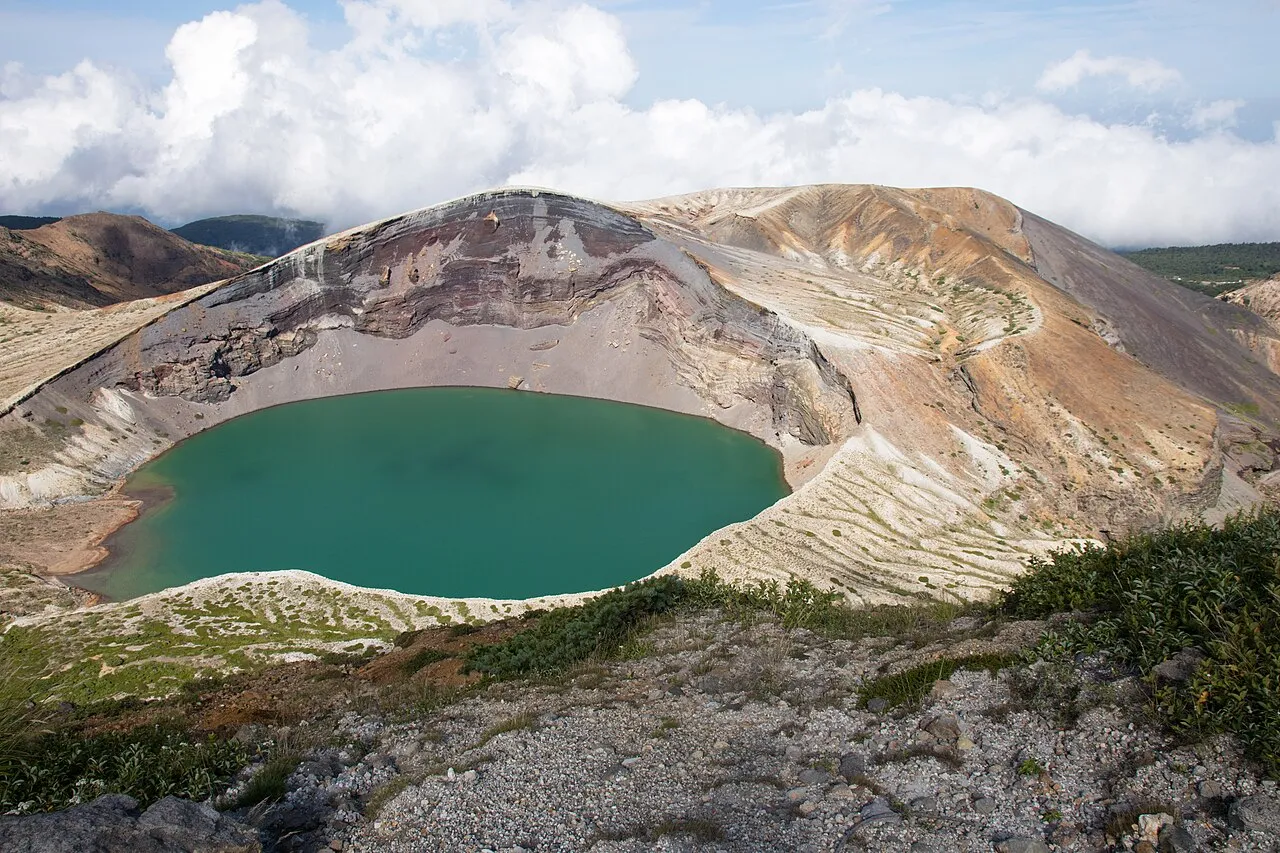
The Mt Chokai and Kisakata area lies on the border of Akita and Yamagata prefectures, covering Nikaho and Yurihonjo in Akita and Yuza in Yamagata. Kisakata has Kujukushima, small islands scattered across rice paddies, and the Chokai Blue Line climbs to Hokodate at Mt Chokai's fifth station. Descending on the Yamagata side brings you to Juroku Rakan Rocks and Maruike-sama Pond.
This guide follows a day from Kisakata over Hokodate to Yuza and gives the Route 7 alternative for when the Chokai Blue Line is closed, with roads and places to stop listed below.
Map of the Mt Chokai and Kisakata area
- Views and nature
- Roadside stations
- 1Michi-no-Eki Kisakata Nemunooka
- 2Kujukushima of Kisakata
- 3Kanmanji Temple
- 4Naso no Shirataki Falls
- 5Mototaki Falls
- 6Hokodate, Mt. Chokai 5th station
- 7Juroku Rakan Rocks
- 8Maruike-sama Pond
- 9Michi-no-Eki Chokai Furatto
- 10Dobara Falls
- 11Nakajimadai and Shishigahana Wetland
- 12Nikaho Highland
- 13Hottai Falls
- 14Michi-no-Eki Nishime
- 15Michi-no-Eki Shimizu no Sato Chokaigo
Line: 1 → 3 → 4 → 5 → 6 → 7 → 8 → 9. The second line is Route 7.
The map could not be loaded. Use the junction-by-junction directions below.
The lines follow the full-day route from Kisakata over Hokodate to Yuza below and the Route 7 alternative. Numbers mark the stops: green for scenery and nature, blue for roadside stations. Tap a marker to see its name.
Recommended drives
First visit: Kisakata over Hokodate to Yuza in a day
From Michi-no-Eki Kisakata Nemunooka, a roadside station, go to Kanmanji Temple and stop at Naso no Shirataki Falls and Mototaki Falls. Climb the Chokai Blue Line to Hokodate at the fifth station, cross the prefectural border and descend to Fukura. Visit Juroku Rakan Rocks and Maruike-sama Pond and continue to Michi-no-Eki Chokai Furatto.
The route is about 51 km, with around 1 hour 5 minutes of driving. Distance and time are calculated from map data and exclude traffic.
In 2026 this route can be driven only until daytime on 4 November. The road is currently closed every day from 17:00 to 08:00, so cross the border between 08:00 and 17:00.
When the Chokai Blue Line is closed: take Route 7
The Chokai Blue Line closes from 4 November at 17:00. The closure runs from the old toll gate on the Kisakata side across the Yamagata border to Komadome Gate. While it is closed, take Route 7 between Kisakata and Yuza.
From Michi-no-Eki Kisakata Nemunooka, stop at Kanmanji Temple, Naso no Shirataki Falls and Mototaki Falls. Then head south on Route 7, visit Juroku Rakan Rocks and Maruike-sama Pond and continue to Michi-no-Eki Chokai Furatto.
The route is about 36 km, with around 45 minutes of driving. Distance and time are calculated from map data and exclude traffic.
Autumn snow and heavy-rain closures
Mt Chokai had its first snow of 2026 on 23 October. On 28 and 29 October, snow closed the Chokai Blue Line all day from Ichinoshimizu Gate to the Yamagata border. Even before the winter closure begins, snowfall can close the road during the day.
After heavy rain on 21 October, the road to Hottai Falls and part of Prefectural Route 58 were closed. On Route 58, Yokooka–Nakajimadai is closed by a landslide, with no reopening date set.
Roads you can drive
| Road | What to expect | Length and cost | Hours and restrictions |
|---|---|---|---|
| Chokai Blue Line (Akita Prefectural Route 131, Yamagata Prefectural Route 210) | From the Kisakata side past Hokodate and over the border to the Fukura side | Closure section: 15.1 km on the Akita side, 14.2 km on the Yamagata side | Closed daily 17:00–08:00 (since 23 October). Winter closure from 4 November at 17:00 |
| National Route 7 | Along the coast between Kisakata and Yuza and Sakata | — | — |
| Nihonkai-Tohoku Expressway, Kisakata IC and Yuza-Chokai IC | Entries north of Kisakata and south of Yuza | — | Yuza-Chokai IC–Kisakata IC is under construction |
| Prefectural Route 58, Kisakata–Yashima Line | From Yokooka in Kisakata past Nakajimadai to Hanadate in Yashima | Closure sections: 22.5 km in total | Yokooka–Nakajimadai closed by a landslide since 22 October. Nakajimadai–Hanadate enters its winter closure on 4 November at 15:00 |
| Prefectural Route 312, Nagaoka–Tooshi–Jonai Line | Links Tooshi on Nikaho Highland with Jonai in Yashima | Closure section: 5.0 km | Winter closure from 4 November at 15:00 |
| National Route 108 | From Yurihonjo towards Higashiyuri and Chokai | — | — |
| City road from Momoyake to Hottai Falls | From Momoyake to Hottai Falls | — | Closed by flooding since 21 October. Winter closure from late November to early May |
The Yamagata side has two closure sections. The 7.8 km from the border to Komadome Gate closes from 4 November at 17:00 until further notice. The 6.4 km from Komadome Gate to Onoso Gate is scheduled to close from 13 November at 17:00 to 5 April 2027.
Places to stop
Views and nature
Numbers match the map.
| No. | Place | Parking | What to know |
|---|---|---|---|
| 2 | Kujukushima | — | Islands scattered across rice paddies; a national natural monument. Visible from the Kanmanji Temple grounds and the Nemunooka observation tower |
| 3 | Kanmanji Temple | Available | Founded in 853. Kujukushima can be seen from the grounds |
| 4 | Naso no Shirataki Falls | About ten minutes' walk from the free car park | 26 m high and 11 m wide; a national place of scenic beauty. Reached down the stone steps of Kinpo Shrine |
| 5 | Mototaki Falls | Available. About ten minutes' walk to the falls | About 50,000 tonnes of water a day emerge from a mossy rock face about 30 m wide and 5 m high |
| 6 | Hokodate, Mt Chokai 5th station | 300 spaces (free) | Views over the Sea of Japan and Naso Gorge. Free visitor centre |
| 7 | Juroku Rakan Rocks | 20 spaces (no large vehicles) | 22 figures carved into the coastal rocks |
| 8 | Maruike-sama Pond | Minowa salmon hatchery car park, 10 spaces (no large vehicles) | A pond filled only by spring water, within the grounds of Chokaisan Omonoimi Shrine |
| 10 | Dobara Falls | 10 spaces | Mt Chokai's underground water emerges from the rocks. About ten minutes by car from Yuza Station |
| 11 | Nakajimadai and Shishigahana Wetland | 100 spaces (free) | Agariko Daio beech and a spring-fed wetland. The full circuit takes about 2 hours 20 minutes. Entry until 14:00 |
| 12 | Nikaho Highland (Hibari-so, south viewpoint) | — | A plateau at about 500 m. Hibari-so has a 360-degree observation deck |
| 13 | Hottai Falls | 100 spaces (10 large vehicles) | Winter closure from late November to early May. The road has been closed by flooding since 21 October |
Roadside stations
| No. | Roadside station | Parking | What to know |
|---|---|---|---|
| 1 | Michi-no-Eki Kisakata Nemunooka | — | Nemunooka 09:00–21:00; Nikahotto 10:00–18:00. Toilets 24 hours. All facilities closed on the third Monday from December to March |
| 9 | Michi-no-Eki Chokai Furatto | 197 ordinary cars | On Route 7. 09:00–18:00 (until 17:00 from November to February). Closed 1 January |
| 14 | Michi-no-Eki Nishime | 89 ordinary cars | 09:00–18:00 (until 17:00 in winter). Toilets 24 hours |
| 15 | Michi-no-Eki Shimizu no Sato Chokaigo | 79 ordinary cars | On Route 108. Direct-sales shop and restaurant closed. Toilets 24 hours |
Best seasons and crowds
| Season | Highlights and cautions |
|---|---|
| Early–late April | The Chokai Blue Line reopens section by section (in 2026, Onoso–Komadome on 6 April and Komadome–border on 24 April) |
| Late April–mid-May | Night closures continue after reopening (in 2026, through 17 May, 17:00–08:00) |
| July–August | Alpine flowers at their best around Lake Chokai at the seventh station (on foot, by mountain trail) |
| Late October–4 November | Chokai Blue Line closed at night. Snow can close it during the day (the first snow of 2026 was on 23 October) |
| 4 November–April | Chokai Blue Line closed for winter. Use Route 7 between Kisakata and Yuza |
Sunset in Akita is at 16:38 on 1 November and 16:24 on 15 November.
Busy places and times
Hokodate draws many hikers and drivers during the season.
The car parks at Juroku Rakan Rocks, Maruike-sama Pond and Dobara Falls hold 10–20 cars. Large vehicles cannot park at Juroku Rakan Rocks or Maruike-sama Pond.
Roads and restrictions checked on 2 November 2026
- The Chokai Blue Line is closed daily 17:00–08:00. The winter closure starts on 4 November at 17:00. Bad weather can bring it forward.
- On Prefectural Route 58, Yokooka–Nakajimadai has been closed by a landslide since 22 October, with no reopening date. Nakajimadai–Hanadate enters its winter closure on 4 November at 15:00.
- The road to Hottai Falls was closed by flooding on 21 October.
- On Prefectural Route 312, Tooshi–Jonai enters its winter closure on 4 November at 15:00.
Getting there and fuel
| Starting point | Approximate drive |
|---|---|
| Kisakata IC | About 20–30 minutes to Hokodate, about ten minutes to Naso no Shirataki Falls, about 15–20 minutes to Nakajimadai (under normal conditions) |
| Michi-no-Eki Kisakata Nemunooka | 15 minutes and 10 km to Mototaki Falls; 25 minutes and 17 km to Hibari-so on Nikaho Highland |
| Sakata-minato IC | 30 minutes to Juroku Rakan Rocks; 30 minutes to Maruike-sama Pond |
| Yuza-hiko IC | About 20 minutes to Dobara Falls |
| Sakata | About 25 minutes to Michi-no-Eki Chokai Furatto |
| Honjo IC | About 1 hour 10 minutes to Hottai Falls |
Refuel in Nikaho or Yuza before going up the Chokai Blue Line.
If you go up to Hokodate at this time of year, fit winter tyres.
If you don't have a car
Use the Akita rental-car listings to find a pickup location. Before booking, check the driving-permit requirements and the equipment supplied for winter driving.
Frequently asked questions
Until when can I drive the Chokai Blue Line?
In 2026 the winter closure starts on 4 November at 17:00. Until then, the road is closed every day from 17:00 to 08:00. Snowfall can also close it during the day.
Can I get from Kisakata to Yuza in winter?
Yes, on Route 7. From Kisakata, stop at Kanmanji Temple or Mototaki Falls and continue past Juroku Rakan Rocks and Maruike-sama Pond to Michi-no-Eki Chokai Furatto. The route is about 36 km, with around 45 minutes of driving.
When does the Chokai Blue Line reopen?
On the Yamagata side, Komadome–Onoso is scheduled to stay closed until 5 April 2027. The Akita side usually reopens in mid-to-late April. In 2026 the border section opened on 24 April, with night closures through 17 May.
Is there parking at Hokodate?
Yes, a free car park holds 300 cars. The visitor centre opens 09:00–16:30, and entry is free.
Can I get to Nakajimadai and Shishigahana Wetland?
Prefectural Route 58 between Yokooka and Nakajimadai has been closed by a landslide since 22 October, with no reopening date. Nakajimadai–Hanadate also closes on 4 November at 15:00.
Nearby areas and guides
Sources & verification
Last verified: 2026-11-02
- Akita Prefecture (official page, in Japanese) · 2026-11-02
- Yamagata Prefecture (official page, in Japanese) · 2026-11-02
- Yamagata Prefecture (official page, in Japanese) · 2026-11-01
- Nikaho City Tourism Association (official page, in Japanese) · 2026-11-01
- Nikaho City Tourism Association (official page, in Japanese) · 2026-11-02
- Nikaho City Tourism Association (official page, in Japanese) · 2026-11-01
- Yamagata Prefecture (official page, in Japanese) · 2026-11-01
- Yamagata Prefecture (official page, in Japanese) · 2026-11-01
- MLIT Tohoku Regional Development Bureau (official page, in Japanese) · 2026-11-01
- MLIT Tohoku Regional Development Bureau (official page, in Japanese) · 2026-11-01
- Nikaho City Tourism Association (official page, in Japanese) · 2026-11-01
- MLIT Tohoku Regional Development Bureau (official page, in Japanese) · 2026-11-01
- Chokaisan and Tobishima Geopark Promotion Council (official page, in Japanese) · 2026-11-02
- Yurihonjo City (official page, in Japanese) · 2026-11-02
- Nikaho City Tourism Association (official page, in Japanese) · 2026-11-01
- Michi-no-Eki Kisakata Nemunooka (official page, in Japanese) · 2026-11-01
- Nikaho City Tourism Association (official page, in Japanese) · 2026-11-01
- Nikaho City Tourism Association (official page, in Japanese) · 2026-11-01
- Nikaho City Tourism Association (official page, in Japanese) · 2026-11-01
- Nikaho City Tourism Association (official page, in Japanese) · 2026-11-01
- Nikaho City Tourism Association (official page, in Japanese) · 2026-11-01
- Chokaisan and Tobishima Geopark Promotion Council (official page, in Japanese) · 2026-11-01
- Nikaho City Tourism Association (official page, in Japanese) · 2026-11-01
- Akita Prefecture (official page, in Japanese) · 2026-11-01
- Nikaho City Tourism Association (official page, in Japanese) · 2026-11-01
- Nikaho City Tourism Association (official page, in Japanese) · 2026-11-01
- Nikaho City Tourism Association (official page, in Japanese) · 2026-11-01
- Yamagata Prefecture (Yamagata Landscape Stories) (official page, in Japanese) · 2026-11-01
- Yamagata Prefecture (Yamagata Landscape Stories) (official page, in Japanese) · 2026-11-01
- Yamagata Prefecture (Yamagata Landscape Stories) (official page, in Japanese) · 2026-11-01
- National Michi-no-Eki Liaison Association (official page, in Japanese) · 2026-11-01
- Yurihonjo City (official page, in Japanese) · 2026-11-01
- National Michi-no-Eki Liaison Association (official page, in Japanese) · 2026-11-01
- Yurihonjo City (official page, in Japanese) · 2026-11-01
- Nikaho City Tourism Association (official page, in Japanese) · 2026-11-01
- National Astronomical Observatory of Japan (official page, in Japanese) · 2026-11-01
- OpenStreetMap (map positions and route; © OpenStreetMap contributors, ODbL; route calculated with OSRM) · 2026-11-01

